TOPOGRAPHIC DATABASE: the Infrastructure for Geographic Information
The continuous evolution and profound changes to which the territory is daily subject, push local governments, to acquire tools always update and updateable, accessible and with a potential of interdisciplinarity as the GIS - Geographic Information System - become indispensable tools for knowledge and territorial government.
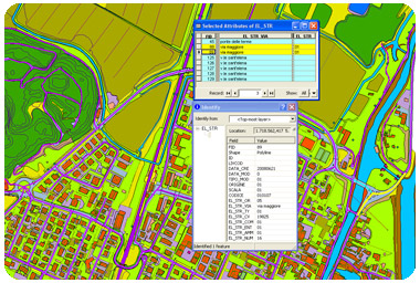
Vector data, that for years provided an invaluable support for the understanding and study of the territory, had seen improve is potential in a exponential way due to this powerful tools that allow conexion to tabular information, and thus making real territory representation far more comprehensive.
Linear elements, areal and punctual, first distinguished by a unique identifier, usually an alphanumeric string are implemented over time with more detailed information which recognized the surrounding elements and / or adjacent to the selected object. This allowed to extend the cognitive but it was limited to information that should be contained in a number of character identification code. The new frontier in the world that manages databases and databanks, allows you to attach to the pivotal structure, mapping a new world more clearly defined and extends from the table structure within which may be defined more fields that can be populated by quantity and quality factors should not stop at only code but also in range of the selected descriptive and explanatory.